


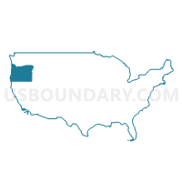
North Central Oregon--The Dalles City PUMA, Oregon
About
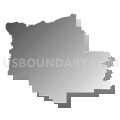
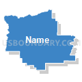
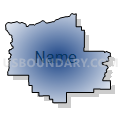
Outline

Summary
| Unique Area Identifier | 193813 |
| Name | North Central Oregon--The Dalles City PUMA |
| State | Oregon |
| Area (square miles) | 18,053.81 |
| Land Area (square miles) | 17,966.74 |
| Water Area (square miles) | 87.06 |
| % of Land Area | 99.52 |
| % of Water Area | 0.48 |
| Latitude of the Internal Point | 44.79636140 |
| Longtitude of the Internal Point | -120.10659730 |
Maps

Graphs
Select a template below for downloading or customizing gragh for North Central Oregon--The Dalles City PUMA, Oregon


Neighbors
Neighoring Public Use Microdata Area (by Name) Neighboring Public Use Microdata Area on the Map
- Clackamas County (South & East)--Damascus City PUMA, OR
- Deschutes County PUMA, OR
- Klamath, Malheur, Lake & Harney Counties PUMA, OR
- Lewis, Klickitat & Skamania Counties PUMA, WA
- Linn & Benton Counties PUMA, OR
- Marion County (Outside Salem & Keizer Cities)--Woodburn & Silverton Cities PUMA, OR
- Multnomah County (East)--Gresham & Troutdale Cities PUMA, OR
- Umatilla, Union, Baker & Wallowa Counties PUMA, OR
- Walla Walla, Benton (Outer) & Franklin (Outer) Counties PUMA, WA
Top 10 Neighboring County (by Population) Neighboring County on the Map
- Multnomah County, OR (735,334)
- Clackamas County, OR (375,992)
- Marion County, OR (315,335)
- Benton County, WA (175,177)
- Deschutes County, OR (157,733)
- Linn County, OR (116,672)
- Umatilla County, OR (75,889)
- Malheur County, OR (31,313)
- Union County, OR (25,748)
- Wasco County, OR (25,213)
Top 10 Neighboring County Subdivision (by Population) Neighboring County Subdivision on the Map
- Bend CCD, Deschutes County, OR (87,281)
- Hermiston-Umatilla CCD, Umatilla County, OR (36,477)
- Redmond CCD, Deschutes County, OR (35,941)
- Sisters-Millican CCD, Deschutes County, OR (27,974)
- The Dalles CCD, Wasco County, OR (20,761)
- Pendleton CCD, Umatilla County, OR (19,339)
- Estacada CCD, Clackamas County, OR (15,451)
- Prineville CCD, Crook County, OR (14,912)
- Hood River CCD, Hood River County, OR (12,456)
- Mount Hood CCD, Clackamas County, OR (10,600)
Top 10 Neighboring Place (by Population) Neighboring Place on the Map
- The Dalles city, OR (13,620)
- Prineville city, OR (9,253)
- Hood River city, OR (7,167)
- Madras city, OR (6,046)
- Boardman city, OR (3,220)
- Warm Springs CDP, OR (2,945)
- Odell CDP, OR (2,255)
- Chenoweth CDP, OR (1,855)
- Irrigon city, OR (1,826)
- John Day city, OR (1,744)
Top 10 Neighboring Elementary School District (by Population) Neighboring Elementary School District on the Map
- Drewsey School District 13, OR (124)
- Juntura School District 12, OR (119)
- Suntex School District 10, OR (85)
- Pine Creek School District 5, OR (52)
Top 10 Neighboring Secondary School District (by Population) Neighboring Secondary School District on the Map
Top 10 Neighboring Unified School District (by Population) Neighboring Unified School District on the Map
- Bend-La Pine Administrative School District 1, OR (107,386)
- Kennewick School District, WA (85,577)
- Redmond School District 2J, OR (45,507)
- Oregon Trail School District 46, OR (28,463)
- Hermiston School District 8, OR (26,789)
- Hood River County School District 1, OR (22,346)
- Crook County School District, OR (21,037)
- North Wasco School District 21, OR (20,509)
- La Grande School District 1, OR (16,990)
- Jefferson County School District 509J, OR (16,028)
Top 10 Neighboring State Legislative District Lower Chamber (by Population) Neighboring State Legislative District Lower Chamber on the Map
- State House District 16, WA (154,830)
- State House District 15, WA (132,788)
- State House District 53, OR (73,781)
- State House District 55, OR (66,629)
- State House District 52, OR (63,241)
- State House District 18, OR (62,291)
- State House District 17, OR (61,383)
- State House District 59, OR (60,455)
- State House District 57, OR (57,718)
- State House District 60, OR (55,458)
Top 10 Neighboring State Legislative District Upper Chamber (by Population) Neighboring State Legislative District Upper Chamber on the Map
- State Senate District 27, OR (155,590)
- State Senate District 16, WA (154,830)
- State Senate District 15, WA (132,788)
- State Senate District 26, OR (126,141)
- State Senate District 28, OR (125,860)
- State Senate District 9, OR (123,674)
- State Senate District 29, OR (119,818)
- State Senate District 30, OR (115,913)
Top 10 Neighboring 111th Congressional District (by Population) Neighboring 111th Congressional District on the Map
- Congressional District 3, WA (779,348)
- Congressional District 4, WA (774,409)
- Congressional District 2, OR (769,987)
- Congressional District 3, OR (762,155)
- Congressional District 5, OR (757,128)
- Congressional District 4, OR (739,234)
Top 10 Neighboring Census Tract (by Population) Neighboring Census Tract on the Map
- Census Tract 10.01, Deschutes County, OR (12,537)
- Census Tract 9501, Klickitat County, WA (8,325)
- Census Tract 9701, Morrow County, OR (7,997)
- Census Tract 9503, Klickitat County, WA (7,769)
- Census Tract 7, Deschutes County, OR (7,670)
- Census Tract 9501, Crook County, OR (7,267)
- Census Tract 12, Deschutes County, OR (6,867)
- Census Tract 9502, Hood River County, OR (6,644)
- Census Tract 6, Deschutes County, OR (6,537)
- Census Tract 9510, Umatilla County, OR (6,259)
Top 10 Neighboring 5-Digit ZIP Code Tabulation Area (by Population) Neighboring 5-Digit ZIP Code Tabulation Area on the Map
- 97701, OR (58,993)
- 97756, OR (33,554)
- 97838, OR (25,346)
- 97058, OR (19,838)
- 97754, OR (18,574)
- 97031, OR (18,375)
- 97741, OR (11,912)
- 97882, OR (7,760)
- 98620, WA (7,123)
- 97760, OR (6,757)